Data structure
This page explores the internal mechanisms of the GLOBALBASE architecture. The GLOBALBASE architecture employs the GLOBALBASE protocol for communication. When communicating according to this protocol, the system exchanges the provided information using a particular data structure in the distributed environment. This way, the browsing functionality discussed earlier can be provided. Let us start with the GLOBALBASE data structure.
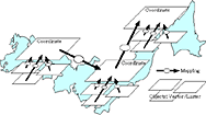
Data provided in the GLOBALBASE system is called resources. Figure 1 illustrates the relationship between resources, i.e., the data structure.
Resources can largely be classified into four types. First of all, the basic resources are the coordinate resources. They define in which coordinate system the provided data exists. For example, they define whether the data is given in a longitude/latitude coordinate system, an xy coordinate system with a particular point as the origin, or an xyz coordinate system, assuming the GLOBALBASE system will be able to handle three-demensional maps in the future. Moreover, they also define the range of a coordinate system, which is very important. For example, a range of x = 0 - 10 km and y = 0 - 100 km can be defined.
In a coordinate system, it is possible to place resources that define actually drawn graphics and pictures, such as luster resources and vector resources. These two types of resources are collectively called object resources. Object resources themselves have implicit coordinate systems. For example, in a luster resource, a coordinate system is formed as a combination of numbers of pixels in the x and y directions.
Lastly, mapping resources define conversions between coordinate systems of individual resources. A mapping resource contains knowledge about the combination of coordinate values of the conversion source and destination coordinate systems. Since an object resource also has an implicit coordinate system, it is possible to find an association with the coordinate system in which the object resource exists, using a mapping resource. Making associations between coordinate systems using mapping resources is called mapping.
In practice, in order to simplify the structure of the system, mapping between two object resources is not allowed. Moreover, object resources must be used by mapping to some coordinate resources. By doing so, one coordinate resource to which one or more object resources are mapped, can be considered as one map, which is very convenient.
It is allowed to map between several coordinate resources, which is referred to as superposition of maps. By mapping between edges of coordinate resources, it is possible to connect adjacent coordinate systems. Moreover, it is possible to define an overlapping coordinate system by defining a mapping where the main parts of two coordinate systems overlap.
A mapping resource is directed from the conversion source to the conversion destination, but this directionality is only required when defining the conversions, and in practice a bi-directional link is provided. However, object resources must always be conversion sources.
Now, if you want to submit map information of the area around your house, you draw an image of the surroundings area of your house and make it an object resource. You then create an xy coordinate resource with an appropriate size and map the object resource to this. Finally, you attach meta-data to these resources, i.e., title and bibliographic information.
The next step is to find map information already provided in the GLOBALBASE system that covers the area around your house. This map can be on a rougher scale than the information you are intending to provide. You can then map the newly created coordinate resource to the part of the map corresponding to the area surrounding your house.
Suppose someone views the aforementioned map you provided using a viewer. The viewer and server operate in concert, but in a distributed manner, and superimpose and display the newly provided map of the area surrounding your house and the map to which it is mapped at the same time. At this point, it is not necessary that the coordinate system matching the search criteria entered in the viewer is mapped to the object resource directly. The server and viewer track multiple mappings, check how the two coordinate systems overlap, and superimpose them.
In a similar way, an information provider does not need to find all existing maps that can be overlapped with the information he or she wants to provide. He or she only need to find at least one proper map.
|
|